I read a lot of stuff about hiking. I scroll through gear makers’ web pages for entertainment. I linger over the pictures at trail associations’ web pages. I read blogs and social media posts. The majority of the time, the backcountry campsites shown or described are *perfect* – idyllic forest scenes, ridgelines with epic views, above the tree line in good weather. It makes me think of the decidedly not perfect campsites I’ve ended up with.
To start, it’s worth noting that the majority of the time I sleep in a hammock. The advantage is that I do not need a flat, clear, dry spot to camp. So long as there are stout-enough trees that are the right distance apart and the ground is relatively clear, I can string up my hammock for a comfortable night’s sleep. I even prefer a bit of a slant to the ground beneath me. It makes it easy to be a safe height above the ground (less than 18″ or so) but by getting in & out of the hammock on the downhill side, I can easily get out. (It can be a challenge to get out of a too-low hammock.) It means I can often camp where no one else can, away from the trail, out of sight. I once camped about 50′ above the PCT on a slope. Folks passed by me, unaware I was there. I was practically invisible.
Sometimes, the trees are the right distance apart and they’re stout enough to support my hammock, but they’re the wrong kind of tree. Subalpine firs are the worst. Their bark is covered in pitch pockets right at the surface that can burst with the slightest pressure. Before I started carrying a strip of Tyvek to put between the hammock straps & the tree, my straps would get pitchy if I used one of these trees as an anchor point. Even with the Tyvek to protect the straps, I try to avoid these trees. But sometimes I have no choice.
One such terrible campsite was Martinson Gap, near Norse Peak on the PCT in Washington’s Section I. There are a lot of burned-out areas in Section I, meaning that finding a safe campsite can be a challenge. Martinson Gap is the only place to camp in an eight-mile stretch of trail. Martinson Gap is very near Tahoma (Mt. Rainier), a dormant volcano that last erupted in the 1890’s. In much of Washington State, the trail is comprised of ashy soil. Martinson Gap is like a sandbox filled with stale flour. It’s very dusty. Despite being dry & dusty, when I camped there the mosquitos were so bad I ate wearing a bug head net. (I treat my hiking clothes with permethrin, so the mosquitos rarely land on me — but that doesn’t stop them from buzzing me constantly and harassing me.)
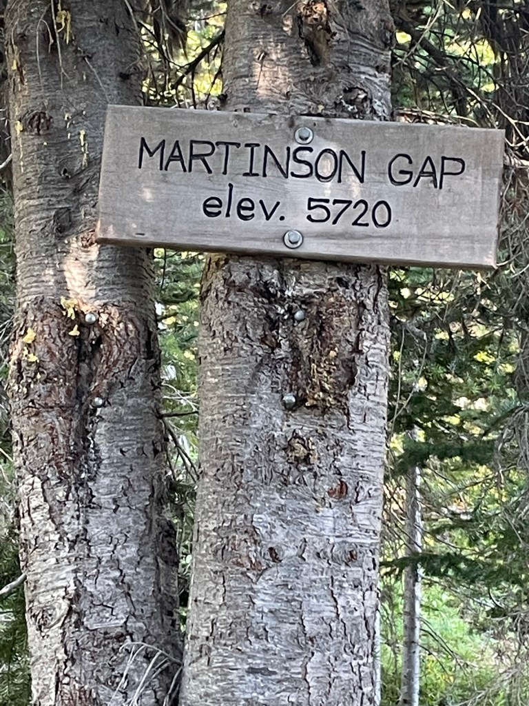
Martinson Gap has space for several tents – maybe as many as a dozen if folks are willing to crowd themselves in. When I’m hiking on a trail as busy as the Pacific Crest Highway, I’m keenly aware of how valuable those safe, flat spaces are for groundlings. Although I was alone, I decided against taking a beautiful spot because it was perfect for a tent, and there isn’t a lot of flat available. I chose to use a sloped area in the trees. It took me three different times – using different trees – to finally get a good “hang.” And even that wasn’t a great hang — I didn’t have the angle of that hang straps right, so I couldn’t lie flat in my hammock. The trees were the right distance apart, but I struggled to find a spot on the tree with no branches to get in the way. (It’s not okay to damage a tree just so I can camp.) And these were subalpine firs, so my hands got pitchy & I got pitch on my shirt trying to set up my hammock.
And guess what? No one else showed up that night. I could have taken the beautiful spot.
I had a similarly bad hang at a place I refer to as “Last Water for Twelve Miles.” It’s a healthy spring a bit north of Martinson Gap. When I arrived, all the decent campsites were taken. I found a place a short way up the trail (NOBO). In addition to all of the defects of my Martinson Gap hang, this site was within a few feet of the trail. It was still early enough that I could have continued, but this was the first time I faced a waterless stretch that long and I wasn’t confident in my ability to gauge how much water I’d need. The next morning, after cameling up for the haul to the next water, I found some glorious spots about 2 1/2 miles up the trail.

Otherwise lovely campsites can have defects. I had a beautiful campsite next to Lemah Creek in Section J, about a half-mile north of the creek crossing. That trip was extremely wet – I got rained on every day for a week. The place where I camped had room for numerous tents and numerous hammocks – it was ideal! I set up my camp and ate huddled under my hammock. Despite how wet everything else was, I slept dry & cozy in my down quilts. (My camp clothes go into a waterproof bag along with the quilts. It’s critical that those things stay dry.) It really was a lovely site. In the morning, as I was breaking camp, I saw a large pile of human poop just a few feet from one of the trees I hung my hammock from – right next to the creek.
I once chose a campsite for its view potential. It’s in the Wind River area of Section H in Washington, along a ridge near Three Corner Rock. It had an incredible view of Loowit (Mt. St Helens), and I was looking forward to watching the sun rise on her slopes. The campsite was largely exposed. In the night, the wind picked up. Suddenly, the thought occurred to me: what am I going to do if a thunderstorm comes through? It takes me forever to pack up my camp in the morning — how fast would I be able to pack up if lightning threatened?
I was lucky — the wind was strong at times, but no thunderstorm forced me from my nest. The dawn came, an Loowit was shrouded in clouds.
Sometimes the spot isn’t terrible, but… This spot overlooks the Trout Creek Valley. Just beyond my campsite, there’s a rock outcropping & the ground drops away. It was a lovely place to eat my dinner. A short bit after dark, a hiker wandered into my campsite. He went around my hammock to the rock outcropping, then returned. “How do I get down?” he asked. I then recognized he thought he was still on the PCT. The path to my campsite was at a bend in the trail, and he zigged when he should have zagged. In September, darkness comes early and the tail end of the NOBO thru-hikers are often hiking well after sunset. I pointed him back to the trail. It was a reminder of how easy it is to get off trail – even one as well marked as the PCT. I also wondered what he thought of me when he first approached — what kind of asshole hangs their hammock across the trail?
I’ve also had my moments of stupidity. I did a loop in the Snoqualmie Pass area: PCT south to Stampede Pass, down to the Palouse to Cascades Trail, back to Snoqualmie Pass. There was trail magic at Stampede Pass, and I lingered far too long, listening to tales from thru-hikers. As I walked along the Palouse to Cascade Trail, I despaired of finding a good campsite. (Had I not lingered, I may have made it back to Snoqualmie Pass that day.) The Palouse to Cascades Trail is an old railway grade. It’s a 40′ wide state park, and the State of Washington only owns the trail – the land around it is private property. Darkness was approaching, and I started looking for some wooded area adjacent to the trail where I could stealthily hang my hammock. One problem was that down here, there were few places with the right size trees the right distance apart without obstructions between them. I finally found a place that almost worked. The trees were a bit too far apart and were not quite stout enough. The weight of me in my hammock caused the trees to lean toward each other a bit – enough so that my rear end touched the ground. On the plus side, if a strap broke I wasn’t going to get hurt in the fall.
The irony? Just a couple of miles up the trail there is an actual campground. Good-sized trees. Vault toilet. Picnic tables. Oh well…
