Short version: I screwed up my food intake, didn’t feel good, gave up.
But no one is here for the short version, are they?
I started off with my pack at about 33 pounds. That’s still heavier than I’d like, but this trip required bear spray — that adds almost a pound — and a week’s worth of food – about seven pounds. I was hoping to be on the road at eight Sunday morning, as that would put us at the trailhead at noon-ish. We left a little later than that, and had a brief delay as we picked up a couple of PNT hikers at the Thirteen Mile Campground. That was worth it, because they’d recently hiked the section I was heading into. It’s always nice to get the most up-to-date information.
Before leaving, I organized the food in my bear bag because I didn’t want to have to completely unload the bag my first night in camp. (I organize by meal type rather than days. That enables me to match the meal to my caloric need for the day & what sounds good at that moment.) Unfortunately, I’d put all my snacks into the bag with breakfasts & desserts, and that bag was at the bottom of a very stuffed bear bag. I didn’t want to empty the entire bag, so I headed out without any readily-accessible food. This was a mistake.
I waved goodbye to The Hubs a little after 1 p.m. and headed up the hill. I started off with the umbrella deployed to give me consistent shade. This was my first real hike with my new backpack, and I had some trouble attaching the umbrella to the shoulder strap. There’s a pouch on that strap that I think is part of the problem, and I didn’t find the pouch very useful. On a future hike, I will remove it try again with the umbrella.
I stopped at the spring near the junction with the Jungle Hill Trail. There’s a large area there for camping. I was feeling the lack of food, so I considered camping there for the night. I elected not to, as I couldn’t find an area for my hammock that was free of dead trees.

I filled my water bag & headed toward the junction with the Wapaloosie Mountain Trail junction. I camped there previously, and I knew I’d find a place to safely hang my hammock.
By this point, I felt like I was close to bonking. It sucks, and it’s the easiest thing in the world to avoid. (And it’s baffling to me that I can eat constantly at home but refuse to eat while on the trail.) I was getting confused — I was constantly certain the camping area was just ahead — and moving very slowly. (I hiked this trail twice in the previous month. It’s still quite familiar.)
When you’re really tired and your brain isn’t firing on all its cylinders, stumbling into a group of cows on the trail is a weird experience.

I wasn’t expecting to have to navigate around cattle again. This group of about a half-dozen were quite wary of me. Fortunately there was no bull this time. But I know that cattle are prey animals, and that instinct remains strong in them. Unlike my encounter with the bull and his herd at the trailhead a few weeks ago, I needed to go through where these cows were standing. I talked in a low voice as I approached and did my best to not look threatening. It worked — I did not get chased by a cow.
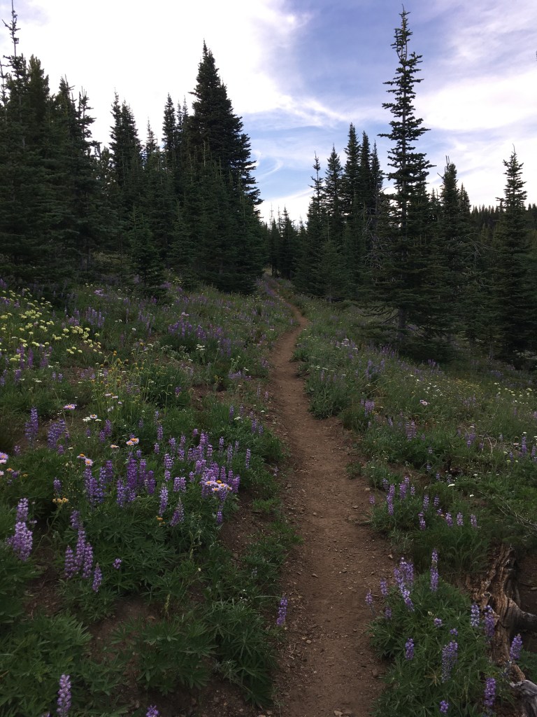
The wildflowers are glorious up there right now. I walked through fields of lupine so fragrant it was inescapable. Note: when you wear a purple shirt while walking through a field of blooming lupine, you attract the attention of a lot of pollinators. The wildflowers were quite lovely throughout my brief trip.


I arrived at camp relatively early. I set up my hammock first, and because of the seclusion of my campsite and the predicted good weather I didn’t put the tarp up. I ate dinner and pondered the next day’s trip. The big unknown on this trail is campsites. This area went through a significant burn about a half-dozen years ago, and there are a lot of dead trees still standing. Even in areas that look like they’d be a good place to camp, one has to keep an eye out for dead trees. (Camping near dead trees is a bad idea because they can fall over without warning. Camping in burned areas is a bad idea because a fire can damage the roots, leaving the tree unstable.) I figured I’d try to make it fifteen miles the next day, but my goal is always to have a campsite selected at least an hour before sunset. (Because this is bear country, the Forest Service recommends against hiking after dark. I have no interest in doing so, either.)
I hung my bear bag well away from my camp and settled in for the night. At 6800′ elevation, the air cools quickly in the evening. Despite my sinuses being a bit clogged – probably the lupines – I slept pretty well. (I felt like I was coming down with a cold.) The night was bright because of the nearly-full moon, but there was enough tree cover that it didn’t keep me awake.
At some point in the night, I heard a noise and saw that a car had pulled up to near where I was camping, and the people inside it got out & were looking around. I knew pretty quickly that I had to be dreaming as there is no way a car could make it to where I was camped. Still, it took a while to shake that feeling.
I got out of the hammock at about 5:30 Monday morning. It was quite chilly. Because I was cold, I skipped my morning mocha drink, and because I apparently enjoy bonking I only ate one cookie. I left camp with just 145 kCal in my stomach. I already had “second breakfast” soaking & I carried that in my waist pack so I can eat while hiking. But taking in that little first thing in the morning was really stupid — I came pretty close to bonking again on Monday. On the plus side, second breakfast was a breakfast parfait that tasted like cheesecake.
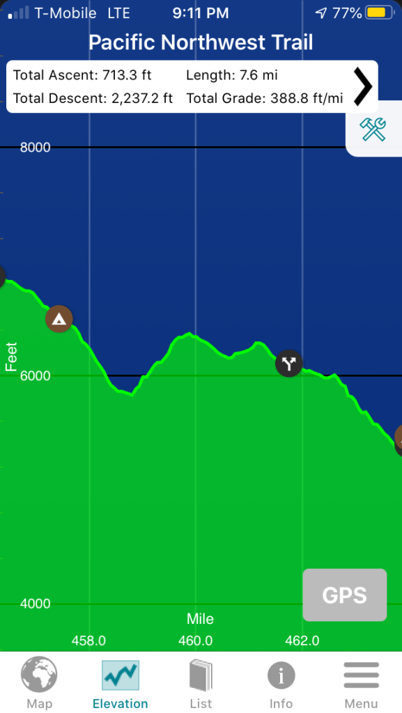
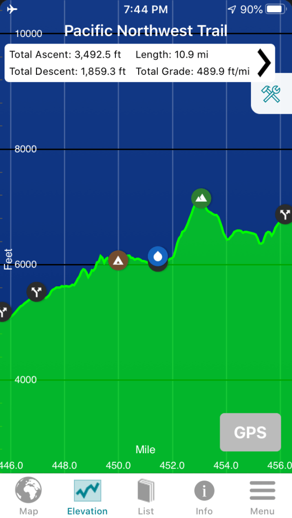
As it turned out, it was a good thing I stopped where I did Sunday night. Despite looking at the elevation profile going up to Copper Butte from the Wapaloosie Mountain Trail junction, I convinced myself it would be a pretty easy hike. It’s about three miles, with about 1,000′ of elevation gain and 745′ of elevation loss. But it felt a LOT harder.
The USGS 7.5 map shows a CGS marker on the top of Copper Butte. I have a fondness for finding these markers that stems from my time serving in USCGC Fir. We’d occasionally use the CGS markers in positioning buoys back when the task was accomplished using horizontal sextant angles. At times, that meant wandering around in someone’s yard with a orange traffic cone I’d place on the marker so that we could see its location from the ship. I researched NGS maps to find new markers for those locations where we had difficulty fixing buoy locations in the hopes of finding new ones to use. That led to wandering around on one of the San Juan Islands and possibly getting hypothermia, but that’s an entirely different story.
There are raspberries growing in the bedframe. 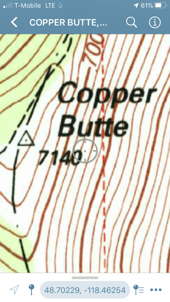
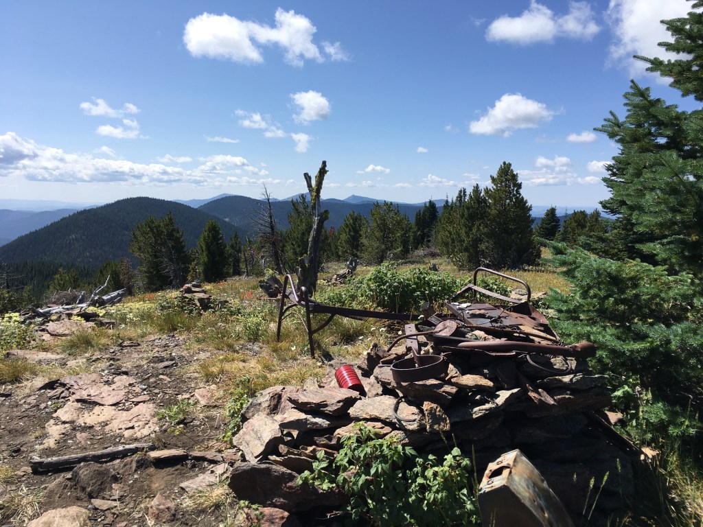
As you can see, the trail bypasses the location of the CGS marker. I wandered to the summit in hopes of finding it. What I found was a bunch of rock cairns, a rusted woodstove, a cache with a sign-in log, an old bedframe, and other bits of detritus. I surmised, and later learned I was correct, that this was the site of a fire lookout. While some trees that have grown to the west now partially block the view, a lookout here would have a 360-degree view of the surrounding area. I didn’t find the CGS marker, and I think it’s beneath the cairn shown in this picture.
Leaving Copper Butte, it’s mostly descending — the trail loses more than 1,000′ in elevation in about a mile. It was slow going because it’s steep, and much of the trail is through a burned area. I most of the day in burned areas. That certainly impacted my mood. (I don’t like steep descent any more than I like steep climbs, either.)

The best campsite I saw all day was at the junction with the Old Stage Road Trail. It was also the last campsite I saw. That would have made for a very short day – just four miles – but I should have listened to the lazy part of my brain that wanted to stop. There’s a spring just a half-mile away — I stopped there for lunch — and I could have a nice, leisurely day.
The rest of the day sucked. I was moving very slowly and growing discouraged. I started listening to music. That lifted my spirits a bit, and then I smelled what I thought was mint. Up ahead, there was a field of mint on the slopes of Mount Leona. It’s blooming, and the flowers were covered with huge bees.

Trail through the mint 
Fuzzy picture of a fuzzy bee
Despite little lifts like this, I was growing concerned. I feared I wouldn’t be able to find a good campsite before dark. I started shifting my focus to finding anything that would work as a campsite, including if it meant sleeping on the ground. I prayed. I was even looking for a flat-enough spot with a large rock I could lean up against if I had to.
I came around a bend in the trial and in the distance saw a stand of live trees. That gave me hope I’d find a safe campsite. As I neared the area, I realized there were still a lot of dead trees. But I found a safe-enough spot. There was a large live tree & a dead-but-still-quite-sturdy tree the right distance apart to hang my hammock. There was a dead tree right next to me, but its diameter is smaller than my forearm – even it fell on me, it wouldn’t harm me. There were two tall dead trees that, if they fell, could have potentially fallen on me. But they were downwind, and there was no wind predicted that evening. While it’s dangerous to camp near dead trees, I decided this site posed less of a danger than continuing to hike and finding myself in the dark without a safe campsite.
I sent Jim a message letting him know I’d camped, that my day had been bad but I was hoping the next day would be better, and that if I didn’t start the tracker in morning it was probably because a tree fell on me. Kind of melodramatic, but I get that way when I’m tired & hungry.
I set up my hammock. I always do a ‘test sit’ to make sure I have the hammock at the right height — not touching the ground, but high enough off the ground it’s easy to get out of. I felt it scrape on a rock underneath me when I did this. I raised it up a bit & continued setting things up. As I was attaching the underquilt, I noticed several scrape holes in the fabric of the hammock. My guess is the rock I felt when I sat in the hammock was a sharp granite one. Now I’m really apprehensive. I patched a couple of the larger holes with Tenacious Tape and hoped for the best.
Because I feared my hammock may tear & dump me onto the ground, I decided I was done with this hike. I told Jim I’d hike out on the Ryan Cabin Trail in the morning, then hike toward to Wapaloosie Mountain Trailhead. He said he’d drive up in the morning.
I started to eat dinner, and found I couldn’t eat. I managed a few spoonfuls, but it was really a struggle. I’m sure most of my friends who are endurance athletes have had this happen: you’re exhausted, starving, but you can’t eat. Normally I would have made myself eat the dinner, but darkness was looming. I needed to get my bear bag tied off to a tree a good distance from my camp.
The night was beautiful. I skipped the tarp again and got to watch the planets & stars shine. Then the full moon rose. I couldn’t sleep, but it wasn’t the moon’s fault. I felt weary & agitated & slighted nauseated. And then I pondered how far I could get away from the hammock before puking if the need arose. (Bear country, remember?)
In the early morning, I heard someone yelling at me for camping in a dangerous spot & setting a bad example and then complaining about how a friend of theirs was blamed for unleashing a pathogen on the public but no one cares when people like me do stupid things. Yes, it was another weird dream. I saw no one on Monday or Tuesday, and there certainly wouldn’t be someone hiking by at 4:30 a.m.
A tree did not fall on me overnight. My hammock didn’t tear. In the morning, I feared I may have been too hasty in my decision to quit. The hike out Tuesday was just as slow as Monday’s had been, but if I’d hiked eight miles I would have reached a camp area with a spring. A short day with a relaxing evening may have been what I needed to get this trip back in order.
Jim met me on the road out. Fortunately for both of us, I stopped at a roadside spring about twenty minutes before. I used the fresh, cold water to clean myself up & remove some of the trail funk. He declared me Not Stinky. With that endorsement, we headed into Republic for lunch.
We’re planning to go camping for a bit. I may try another hike next week. I have more than a week’s worth of hiker meals. If I cannot use them in the next month, I’ll need to vacuum-seal them to prevent them from going bad. (The food is great, but it’s really calorie dense. It’s not kind of stuff I can eat on a daily basis.)
While I wasn’t feeling great and I over-estimated my ability & underestimated how hard the trail was, I think the biggest take-away from this is that I’m out of shape. I’m not as out of shape as I was a decade ago, but a decade ago I was ten years younger & things like this didn’t wear me down as much as they do now. I really need to get back into condition. I worked too hard to get into shape to let it all fade away.

Your parents really messed up your life!!!
LikeLike
This one’s on Covid-19. And I think my parents get the credit for my love of the outdoors, my ‘can-do’ spirit, my tenacity, and my ability to admit when I’m beat.
LikeLike